Duration: (13 Nights and 14 Days Treks)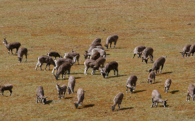
These treks take 14 days. Height goes from sub-topical to above 5000m in northern belt. This is one of most beautiful treks route in Bhutan. This treks also called “Beautiful Laya Gasa Treks.” Trekkers get to see so many different species of flora and fauna. Pass by many herders from different tribes.
Day 1 Paro
– In an unforgettable flight giving you an adrenaline rush as you see views of Mount Everest, Kanchenjunga and other famous Himalayan peaks, including the sacred Jomolhari and Mount Jichu Drake, you will land at Paro International Airport. The landing at Paro, considered one of the most challenging will also be an enthralling experience.
Our company’s representatives will receive you at the airport. After a brief stopover in a hotel, your Bhutanese expedition will begin with visits to places of historical importance in Paro. It will be the National Museum of Bhutan, the Majestic Paro Rimpong Dzong and Kyichu temple, one of the oldest temples in Bhutan built by King Songtsen Gyempo of Tibet in 659AD.
Day 2 Paro
- Hike to Tiger Nest Monastery, one of the holiest monastereries in the Buddhist World
- Over night at hotel in Paro.
Day 3 Trek begins
- Drukgyal Dzong to Shana.
- Drukgyel Dzong, end of peace road, trekking crews and pack horses will meet. Trails follow farm road and through farm road till Metshena Suspension bridge. Gradual climb through the rice field for two hours and reach to Chorten, it is good sport for lunch sport. Trail follow through pine wood forest and reach to Army check post where required special treks route permit from Army Head Quarter. After 10 minutes cross the nether suspension bridge to left side of Paro chu. Thirty minutes to reach to camp.
Day 4
- Shana to Thathangka
- Today is longest and hard day. The trail is rough and stony with many rises and drops through different vegetation zone. Crossing Paro River two time till reach to camp site.
Day 5
- Drukgyal Dzong to Shana.
- From Drukgyel Dzong, trek begins, following a farm road and through farm road till Metshena Suspension bridge. Gradually climb through the rice field for two hours and reach a Chorten (stupa), a good spot for lunch. Trail then follows through pine wood forest until you reach the Army check post where you pick required special treks route permit. After 10 minutes cross the suspension bridge to the left side of Paro chu. Walk for thirty minutes to reach to camp.
Day 4
- Shana to Thathangka
- Today is longest and hard day. The trail is rough and stony with many rises and drops through different vegetation zone. You cross Paro River two times till reach to camp site.
Day 5
- Thathangka to Jangothang
- After an hour walk from camp you reach an Army camp. After that trail goes through wide open river valley pass, where you see many yak herder’s permanent houses.
Day 6 Halt
- Halt the day to explore around in many different directions. There are five different places you can explore around. Or take rest and do laundry.
Day 7 Trek
- Jangothang to Lingshi
- Walk towards the north following the river end of the last house in Soe valley, and cross the small wooden bridge and start steep climb for one hour. Walk through the wide open meadow and again start climbing to Nelela pass(4890m). From the pass, decent down 40 minutes; a good place for lunch. After lunch cross the small stream and follow the ridge and drop down to camp.
- Thathangka to Jangothang
- One hour walk from camp reached to Army camp. After army camp trail goes through wide open river valley pass by many yak herder permanent houses.
Day 6
- Halt
- Halt day explore around in many different direction. There are five different places can explore around. Or take rest and do laundry.
Day 7
- Jangothang to Lingshi
- Walk toward northern direction following the river end of last house in Soe valley, cross the small wooden bridge and start steep climb for one hours. Walk through the wide open meadow till again start climbing to Nelela pass(4890m). From the pass, decent down 40 minutes there is good place for lunch. After lunch cross the small steam and follow the ridge and drop drown to camp site.
Day 8 Day 6: Lingshi – Chebisa (Distance 10km, five to six hours, 280m ascent, 410m descent, camp altitude 3,880m).
You can take the trek today easy as it is the shortest walking day. Shortly after starting you will reach a chorten below Lingshi Dzong. Here, you have the choice of staying on the main trail or taking a diversion up to the Lingshi Dzong (4,220m), which sits right atop a ridge. Besides a very special atmosphere of mystic silence Lingshi Dzong provides a great view over the valley. After Lingshi Dzong you will be passing the villages of Lingshi and Goyul. In Goyul, the stone houses are clustered together to a small compact village that is unusual in Bhutan where village houses are normally scattered. On reaching the campsite at Chebisa with a beautiful waterfall behind the village, you will have plenty of time to visit the village houses if you feel up to it.
Day 7: Chebisa – Shomuthang (Distance 17km, six to seven hours, 890m ascent, 540m descent, camp altitude 4,220m)
You walk through a wide pastureland towards Gobu La (pass). On the way, you will see a few people herding yaks. There is also a great chance to spot large herds of blue sheep above the trail. After crossing the Gobu La (4,410m), you descend to the valley, then climb again a little bit, and descend again to Shakshepasa (3,980) where a helipad has been established. Climbing from here you will finally reach the campsite at Shomuthang, above a river, which is a tributary of the Nochu river.
Day 8: Shomuthang – Robluthang (Distance 18km, six to seven hours, 700m ascent, 760m descent, camp altitude 4,160m).
As the walk is a little strenuous, it is advisable to start early. You climb up the valley to view Kang Bum (6,526 m) and some edelweiss. After two hours of climbing you will reach Jhari La (4,750m), from where you catch the first sight of Sinche La, the pass you will have to cross the day after. The big snow peak in the north is Gangchhenta 6,840 m, better known as the Great Tiger Mountain. If weather is clear, Tserim Kang and the top of Jumolhari will be visible. The camp by the river is called Tsheri Jathang. Herds of takin, the Bhutanese National Animal, migrate to this valley in summer and remain for about four months. The valley has been declared a takin sanctuary. Climb up a little bit and you will reach the campsite at Robluthang in a rocky meadow.
Day 9: Robluthang – Limithang (Distance 19km, six to seven hours, 850m ascent, 870m descent, camp altitude 4,140m).
After crossing Sinche La (5,005m) – the last and highest pass on the trek in case you don’t intend to continue the Snowman trek from Laya onwards – you descend to a little stone house where a few Laya women – dressed in typical Laya costume with long pointed bamboo hats on their head – live and offer their weaving products. Right behind the stone house you will see an impressive terminal moraine and a glacial lake at the foot of the valley. You can see classic examples of the lateral moraines where the glacier has pushed rocks up both sides of the valley. Below the moraine, you cross the Kango Chhu and soon reach the Limithang campsite. The peak of Gangchhenta towers over the campsite even though it’s quite a distance away.
Day 10: Limithang – Laya (Distance 10km, four to five hours, 60m ascent, 340m descent, camp altitude 3,840m).
Today, you walk all the way downhill along a narrow winding river valley. After a long time, you again trek partly through deep forest. The trail leads you to the west side of Laya village. From the west of the village you will view Gangchhenta again and catch a glimpse of Masagang. In the village centre is a community school and a basic health unit with telephone connection. The campsite is below the school.
Day 11: Laya – Koina (Distance 19km, six to seven hours, 260m ascent, 1,070m descent, camp altitude 3,050m).
The trail winds up and down along the river valley of Mo Chhu avoiding natural obstacles and affording breath-taking views of the crashing river, feeder streams and water falls. Lots of ups and downs will lead you to Kohi Lapcha at 3.300 m. The trek then drops down to the large stream of Koina Chhu, where you will find the campsite of Koina.
Day 12: Koina – Gasa (Distance 14km, six to seven hours, 740m ascent, 1,500m descent, camp altitude at Gasa Tsachu 2,240m).
Today you will have your last major climb of the Laya Gasa Trek. You will cross the Bari La (3,740m), after which the trail is all the way down till you reach Gasa village (2,770m), where you will find the first restaurants since starting from Drukgyel Dzong. There also is a campsite close to Gasa Dzong ( You will have to decide if you want to stay in Gasa village or descend for another one hourto the Gasa Tsachu (hot springs) and relax in the thermal water. The Gasa Tsachu is one of the most popular hot springs in Bhutan.
Day 13: Gasa – Damji (Distance 18km, five to six hours, 480m ascent, 470m descent, camp altitude 2,250m).
After a short climb, the trail winds through lots of ups and downs, through rolling hills and passes and pine and oak forests, villages and wheat fields. You will also see a beautiful view of the Gasa Dzong glued to the valley wall as if floating in space. You finally reach Damji with its well maintained campsite.
Day14: Damji – Tashithang (Distance 16km, five hours, 250m ascent, 870m descent).
The trail descends from the high agricultural benches above the Mo Chhu into a lush semi-tropical gorge filled with banana trees, creepers and various tropical vegetation. You will also see monkeys and a few other animals occasionally. The road actually leads further up than Tashithang and will soon reach Damji. You can save about two hours of walking when you arrange transport from the current roadhead.
- Lingshi to Chebisa
- Start climb toward Lingshi Dzong, 100m below the Dzong, trail goes down to Lingshi school. Today walk is gradual and beautiful walk along the ridge and passing by isolated village called Gongyul. After two hours walk from Gongyul village reached to nether small village where will camp to night.
Day 9
- Chebisa to Shakeyapasang
- It is steep climb from the camp to Gogu La pass(4440m), while climbing may see herds of Blue Sheep and Himalayan Griffin flying over your head. From pass decent down hill into the rhododendron trees and fir forest. Finally reached to open river valley and other side of river is our camp site.
Day 10
- Shakeypasang to Robluthang
- Day start 230m climb to yaks herder camp and trail follow the steam source coming from Jeri la. After one hour walk along the steam, then again starts climbing to Jeri La pass (4780m). From Jeri La get good view of Gangchen Ta or Tiger Mountain (6840m) and to Robulathang camp site. Drop down hill through fir forest and reach to open valley. In the summer season hundereds of Takins (National Animal of Bhutan) migrate in these areas. One hour climb to camp site.
Day 11
- Robluthang to Ligmethang
- The trail follows many moraines dam and walk along the steam source coming from Sing Chen La. Two hours continues walk, start steep zigzag climb to Sing Chen La pass(5000m). Three hour drop down to river valley, following the steam lead to Ligmethang camp.
Day 12
- Ligmethang to Laya
- Today there is no major pass to cross but there is climb through the dense coniferous forest. Cross two major river bridges which come from Tiger Mountain. Camp in the Laya villages.
Day 13
- Laya (Halt Day)
- There are many places can explore around the Laya, depending on once interest. Walk around the villages and visiting temples. If you are adventurous take four hours walk to climb top of Rocky Mountains at the top of Laya village. There is nether option to visit Yellow and Black lake behind the Laya village.
Day 14
- Laya to Koina
- The trail leaves through farm houses and field. After 5km reach to Army camp, and follow the Mo chu river for around one hours and cross the river on right side of rive. Than trail starts gradual climb cairns and trail drops down to Camp
Day 15
- Koina to Gasa
- From camp site trail start climb on the other side of ridge until Bari La pass(3900m). After pass trail drops down and pass few land slide area.
Day 16
- Gasa to Punakha
- Walk down to Same Chu bridge where road is connected from Punakha. Follow the new road for one hour, where car will be waiting with fresh refreshment to serve.
Day 17
- Punakha to Thimphu.
- Visit Punakha Dzong which played an important role in the olden days. It was Bhutan’s second monastic school after Cheri Monastery. The first king was crowned inside this Dzong in 1907. It is residence to the Central Monk Body and Je Khenpo (Chief Abbot) in winter.
- Hike to Chimi Lhakhang through a good walk along the paddy fields and farm houses. The temple was built by Lama Ngawang Chogyel in 1499 and is today a popular temple where barren women come to pray for a child. The temple is popularly known as the Fertility Temple.
- Stopover on the way at enchanting Docula pass (3040m above sea level). On a clear day one can see panoramic view of the Eastern Himalayan Mountains ranges, which had came across during your treks.
- Over night in Thimphu.
Day 18
- Thimphu – Paro.
At Thimphu, Thimphu has a lot to offer and your day will begin with visits to the Memorial Chorten, one of Bhutan’s most beautiful stupas built in memory of the Father of Modern Bhutan, Third King Jigmi Dorji Wangchuck. The next visit will be to Buddha Point, where stands the gigantic world’s largest Buddha Statue. You will then move to the 12th century Changangkha monastery, followed by the Takin Zoo and a drive to Sangaygang, a point from where you can have a bird’s eye view of Thimphu valley.
From there we move to the Handicraft’s center, the Local Bhutanese Paper making factory, a Nunnery and the Arts and Craft School.
Drive to Paro.
Day 19
- Depature from Paro.