
Bhutan is located between the world’s two most populated countries, China in the north and India on other sides.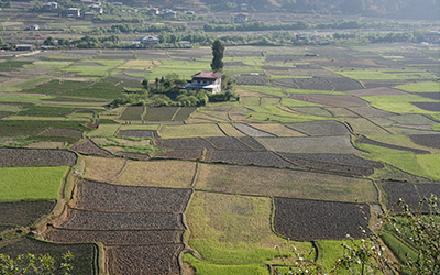
With land area of about 46,500 square kilometres, geographically Bhutan lies between latitudes 26 degree 45 inches North and longitudes of 88 degrees 45 inches E and 92 degrees 10 inches E.
It is a relatively compact nation with a maximum latitudinal distance of 170 kilometres and the maximum longitudinal distance of 300 kilometres. It is about 200 air miles in length and about 100 air miles in breadth.
The Himalayan country is dominated by the Himalayan ranges interspersed by enchanting deep valleys where pristine rivers flow. The mountains stand to the North, South and Central parts of Bhutan along with the main river valleys and passes. These affect the climate and Bhutan experiences differences in elevation and degree of monsoon.
Bhutanese land rises from approximately 300 meters above sea level in the south to the towering Himalayan Mountains in the north of over 7,000 meters high. The country is divided into three geographical regions: the Greater Himalaya, the Inner Himalaya and the Southern foothills.
The Greater Himalayan region lies along the Tibet anborder. This region is inhabited by two groups of pastoralists: known as “Jobs” in the west and “Brokpa” in the east.
Some of the mountains along the Bhutanese border with Tibet are more than 6,000m in height, featuring the following peaks:
- Mt. Jomolhari (Mountain Goddess) at 7314m
- Gangkar Punsum at 7500m(world highest unclimbed mountain)
- Tshering Gang at 6900m
- Jichu draki(6890m)
- Masang Gang (7000m)
This region is characterized by cold climate conditions with winter temperature often below freezing point and area covered under a blanket of snow.
Besides herding yaks, the pastoralists also cultivate grains like barley and vegetables such as, potato, turnip and radish. This region is very sparsely populated and the people living here lead a nomadic life, moving from one pasture land to another with their yaks. Barter Trade is still practiced here, with the trade involving partners from the south, to supplement their own produce.
This region extends from the west to east between the Greater Himalaya in the north and the Southern foothills. In the centre part of this region, the climate is generally moderate with warm summer and very cold winter, where snowfall is experienced occasionally.
The Black Mountains in centre Bhutan spans from the north to south, dividing the country into the eastern and western parts. Eastern Bhutan is mostly humid with relative amount of rainfall while the Western part is mostly cold and dry. Central Bhutan, consisting of the Inner Himalayas, which rises gradually to about 3000 meters. This region consists of the broader river valleys of Paro, Thimphu, Punakha, Wangdiphodrang, Trongsa, Bumthang, Mongar and Trashigang. These valleys are the economic and cultural heartland of the country.
The Southern Foothills extends over the plains of the Indo-Bhutan border. The foothills rise from the Indian plains in the south at 600m till the steep escarpment to more than 1500m. The region is characterized by hot, humid climate with warm summer. The annual average rainfall is about 500cm and average temperature of this subtropical monsoon region is 25 degree Celsius. Tropical deciduous vegetation is found in abundance in this region.
Densely populated, the region houses nearly one third of Bhutan’s population. Land is intensively used to cultivate rice, maize, millet, wheat and many other topical fruits including banana, mango, orange, papaya and jackfruit. It is comparatively more developed because of good road infrastructure and low transport cost.
All rivers in Bhutan have their source from the Himalayas in the north and flow southwards to the Brahmaputra in Assam, India and finally into the Bay of Bengal. Almost all valleys have perennial rivers or streams which merge ultimately into four major river systems: the Ammochu, Wangchu, Sunkosh and Manas. The rivers, fed by the perennial snows or the summer monsoon, are higher in monsoon season (June to September) and lower in winter (December to March).